6,000 BC The sea level stabilized after the melting of the ice caps. It is thought that Aboriginal people left the island at this time, probably because of remoteness, loss of tidal food zone and harshness of the terrain.
1,500 BC Midden evidence shows that Aborigines returned at about this time. Early European contact noted about 200 people on the island.
Quandamooka Yoolooburrabee Aboriginal Corporation
16 May 1770 Captain James Cook in the Endeavour named Cape Moreton. The body of water between North Stradbroke Island and Moreton Island (Mulgumpin) he named Moreton Bay. The name was taken after the Scottish Earl of Morton, then the president of the Royal Society. Cook also named what we now call Moreton Bay 'Glass House Bay' after naming the Glasshouse Mountains on the adjacent mainland.
1793 Misspelling of Morton occurred in Hawksworth's translations of Cook's journals.
14 July 1799 Matthew Flinders arrived in the Norfolk to explore and chart 'Glass House Bay'.
31 July 1799 Flinders discovered that the land south of Cape Moreton was in fact an island and named it Moreton Island (Mulgumpin) following Cook's trend. Glass House Bay became Moreton Bay. Cook hadn't been able to determine its island status as the South Passage Bar was too dangerous for a closer look, and he didn't enter the Bay at Cape Moreton.
January 1823 Pamphlett, Parsons and Finnegan, ticket-of-leave convicts left Sydney to fell timber at Illawarra. They were caught in a storm, blown north and after 21 days at sea with very little water, desperate and near death, managed to beach their boat on Moreton Island (Mulgumpin). When they had recovered sufficiently with the help of the Aborigines they made their way to the southern end of the island via the western beach and were transported to Stradbroke Island in a canoe.
They were treated very hospitably by the Aboriginal people for their stay of a week or ten days. They were accommodated in a large hut of their own and supplied food, water and any other necessities.
The Europeans were not permitted to approach the women's huts for the first five or six days and at night younger men would sleep outside their hut. Afterwards, they were less vigilant and the white men could pass through the huts of women as they pleased. The survivors were then canoed to the mainland.
29 November 1823 John Oxley, on expedition to find a suitable place for a penal colony with fresh water discovered Thomas Pamphlett running along the beach with some Aborigines. The survivors had discovered the Brisbane River while attempting to head back to Sydney and could show Oxley the site which today is Brisbane.
September 1824 The first European settlement in the vicinity was established at Redcliffe. Called Moreton Bay settlement, it was later moved to its present site of Brisbane.
1824 - 1850 South Passage was the main entrance into Moreton Bay.
1825 Moreton Island (Mulgumpin) aboriginals were ravaged by smallpox.
1826 Small pilot station established at Amity Point on North Stradbroke Island
1833 Moreton Island (Mulgumpin) aboriginals suffered a massacre at the head of the large lagoon at the southern end of the island (now eroded into the Bay). The attack was apparently the last in a series of reprisal attacks between Aboriginals and soldiers stationed on Nth Stradbroke Island.
1842 Moreton Bay district opened to free settlement.
1846 Storm Mountain and Burnett Peak were named by J.C. Burnett, surveyor on board the survey vessel Bramble, charting the northern sand banks and passage out of Moreton Bay.
11 March 1847 Wreck of the Sovereign, a 119 ton paddle steamer, in the South Passage. Forty four people drowned and most of the recorded bodies were buried on Moreton Island (Mulgumpin). Ten passengers were rescued by natives from Moreton and Nth Stradbroke Islands. As a result of this shipwreck, use of the South Passage was discouraged.
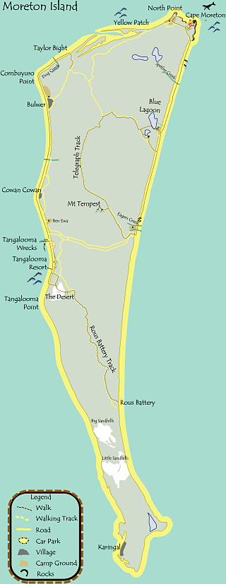
August 1848 Amity Point pilot station moved to Bulwer on Moreton Island (Mulgumpin). The township of Bulwer was named after Edward Bulwer Lytton, a novelist, playwright, British MP and Colonial Secretary at the time.
1848 - 1909 Pilots at Bulwer guided ships into the channel. The township established quite a community, including a school.
1850 Aboriginal survivors were forced to move to North Stradbroke Island.
31 October 1853 The 329 ton barque, Countess of Derby, en route from Sydney via Cleveland to London with wool and other cargo, struck the South spit and stayed there. No fatalities.
1855 The growing importance of the settlement at Brisbane resulted in greatly increased shipping activity.
14 March 1855 Aurora, a migrant ship from Hamburg carrying 300 passengers, tried to negotiate the South Passage without charts or assistance and ran ashore on the seaward side of the southern end of Moreton Island (Mulgumpin). All passengers were safe, but the ship was wrecked.
21 November 1855 Venus was totally wrecked on the present day Venus Shoal while entering the Bay. She was sailing from Manilla to Melbourne with a cargo of sugar. All crew were saved.
21 September 1855 A light consisting of a revolving lantern, a hand wound mechanism to drive it and 21 oil lamps with reflectors had been built in London for £1,419 and arrived with 45 cases of machinery and a light smith, Thomas Heck.
18 February 1856 Tenders called for the erection of a lighthouse at Cape Moreton
1857 The 23m high tower was constructed of 60cm thick locally quarried sandstone blocks by 35 good conduct civil prisoners. The iron ring bolts used for the tackle to hoist stone blocks to the upper walls still remain in the lowest wall. The lighthouse was built by the NSW Government at a cost of £15,232.
1857 Juno, a 212 ton barque ran aground on Moreton Island (Mulgumpin) and was a total loss.
1858 The Cape Moreton lighthouse, standing 95m above sea level at the North East extremity, commenced operation. The original oil lamps and clockwork mechanism have since been replaced by electric arcs and motors and a 6 amp bulb reflected through a series of upward spiralling crystals. The first super-intendant was James Brayden.
1859 Queensland achieved seperate identity from New South Wales and became a self governed colony.
5 October 1859 Marina a 529 ton barque, was grounded on the Barrier Reef and abandoned by her crew. Soon after, Sapphire was also wrecked and her crew in boats came across Marina, which looked sound. The crew of the Sapphire proceeded to Port Curtis and then on towards Sydney in her. Passing Cape Moreton her seams opened and she started to sink. The crew came onto the Tom Tough and the Marina was burnt till she sank.
1862 Friends a schooner, was found upside down on the southern most point of Moreton Island (Mulgumpin). One body, in an advanced state of decay was buried on the beach. No other crew had been heard of. The ship had been missing for two months.
25 February 1863 Notification of sales of land at Bulwer.
19 March 1863 904 ton Everton ran aground near Cowan Cowan.
1863 Mrs. Barnfield, a passenger of the immigrant ship Queen of the Colonies was buried on Moreton Island (Mulgumpin).
1865 Goats and pigs were left on the island by the navy as food for shipwrecked sailors. Goats were also kept at the headland as a source of food for the lighthouse keepers. Traditionally, goats have been placed at lighthouses and headlands along the coastline but at Cape Moreton they have removed so the erosive damage caused can be repaired.
1870 Watkins and Heston collected information on the Aborigines of Moreton Island (Mulgumpin). The island had been virtually ignored by white men until the advent of the pilot station and lighthouse. Even then, the effects on the island and it's people were minimal and information collected was fairly uncontaminated by customs and language merging.
31 May 1872 Young Australia, a 1020 ton wooden ship, wrecked on the rocks at North Point near Cape Moreton when a flat calm occurred and she drifted to the shore. All passengers and crew safe, but the ship and cargo were lost.
1874 A signal light established at Cowan Cowan Point.
17 March 1875 The 289 ton barque St Magnus capsized after having to stand out in heavy seas off Cape Moreton.
1883 Heath Island named after Captain Heath who cut the 'old' or Koopa bar at this time.
7 November 1883 Grave was established just south of Bulwer with a sandstone headstone and wrought iron fence for William Alexander Leslie who died at sea and was ferried ashore for burial aged 11 months 3 days.
13 July 1888 The schooner Spunkie sunk after it collided with the steamer Ranalaghi off Cape Moreton.
16 July 1889 The 850 ton Danish barque Gerd Heye was wrecked on the ocean side of Moreton Island (Mulgumpin) near the sandhills. The remains are buried in the sands of Moreton Island (Mulgumpin). No lives were lost and the crew were found by an officer of the telegraph station, looking for a break in the telegraph wire.
1890s Telegraph line to the lighthouse established.
24 February 1894 The Danish barque Aarhus (640 tons) was wrecked on Smith Rock en route from New York to Brisbane. When the pilot did not arrive the captain decided to put to sea for the night. The ship hit Smith Rock and in 15 minutes was 12 fathoms under. Fourteen of the crew, including the captain and his wife, rowed 3 hours to shore on Moreton Island (Mulgumpin).
14 March 1894 The Grace Darling, a 69 ton schooner, was moored off Bulwer for three days in Heavy south east winds with a full cargo of dynamite and coal. On the fourth day, the ship lost anchors and stranded. The crew were safe, but the schooner was a total wreck.
30 April 1895 Grave of Dorothy Newnham, aged one year, who died in her sleep at sea and was ferried ashore to be buried beside the other child's grave south of Bulwer. This grave has a marble headstone and a picket fence.
1899 Cowan Cowan Lighthouse established.
Early 1900s The original community of Boolong was surveyed in the early part of the century. Its location, Clohery's Peninsula (named after the Boolong lighthouse keeper) was eroded by the sea, taking the lighthouse with it. Boolong had been home for itinerant squatters, fishermen and the lighthouse.
Pre World War I Kalatina, belonging to John Burke, was scuttled at Bulwer, just south of Comboyuro Point.
1914 Frank Day worked the telegraph line.
26 March 1914 St Paul, a 1660 ton French steamer, hit Smiths Rock with a load of chrome ore from New Caledonia. Eighteen of the twenty nine people on board died.
1914 - 1918 World War I saw the establishment of Cowan Cowan as a defence base. It gained a jetty, two government ships based there and a signal station on the hill behind, which Harry Wadsworth used to cross the swamp to light each evening. At the end of World War I, Cowan Cowan acquired a gun, staffed until World War II.
1 July 1915 Cape Moreton lighthouse transferred from New South Wales government to Commonwealth control.
1 November 1916 Grave of Edward Jones aged 78 found in bush east of Kooringal township.
13 October 1917 The last Aborigine who had lived traditionally on Moreton Island (Mulgumpin), Sydney Rowlan, died at the age of 88, leaving her son Sam, who was the last of the islands dugong fishermen.
1920 Frank Day grew cultured pearls on the banks of Kooringal.
1930s Three ships were scuttled to form a small craft harbour near Bulwer township. The northern hulk is the 716 ton Mount Kembla. A 646 ton passneger and cargo ship, Kallatina, forms the southern side, while the western hulk is the 337 ton steamer Hopewell.
Mid 1930s Two ships were beached about 8km north of Kooringal on the island's west coast. The 98 ton steamer Normanby lies to the south while the 315 ton Fairlight is the northern hulk.
11 June 1938 The 50 ton MV Atlantic struck Flinders Reef and was wrecked with the loss of one life.
7 July 1942 Rufus King, an American liberty ship ran aground in South Passage during light rain and broke up. All the cargo (nine Mitchell Bombers in crates, aviation fuel and medical supplies) was recovered and the front half was sealed and towed to New Guinea as a floating workshop. No lives lost.
1943 During World War II, 900 troops were stationed on the island, the encampments being at Cowan and Toompani Beach. Both installations are being gradually claimed by the sea. Rous Battery Road was constructed by the army, a jetty and naval station were established at Tangalooma and Middle Road was constructed.
1947 Small amount of mining exploration was undertaken.
1948 Frank Day worked with troops at Cowan Cowan.
1950 A company called Whale Products PTY LTD established in Sydney for the purpose of carrying out whaling off the east coast of Australia. After a feasibility study it was decided to base activities at Tangalooma.
1950 The 7326 ton British freighter Marietta Dal broke in half on Smiths Rock. No lives were lost. Only some of the £500,000 cargo was salvaged.
1951 A 30 year lease over 12ha was gained for construction of a whale processing plant. Whale Industries Ltd took over from Whale Products Pty Ltd and secured a five year license for the taking of 600 humpback whales per season in a 240km2 area north, south and east of Tangalooma.
1952 - 1962 Tangalooma Whaling Station began operation as Queensland's only whaling station. Tangalooma was selected as the site because of its relative protection, access to fresh water and proximity to Brisbane and the migration path of the humpback whales just off Cape Moreton. The station consisted of a factory surmounted by a flensing deck with a log ramp into the Bay to land whales, a jetty, steam generator and staff accommodation. The season lasted from June 1st to October 31st. The station could handle eleven whales per day, requiring 140 staff for the season and twelve for the rest of the year. The station proved to be a very successful operation.
1952 Telegraph line to the Cape abandoned.
1955 Extensive mining exploration undertaken leading to a short period of mining.
June 1956 Formation of Tangalooma Minerals Pty Ltd
1957 - 1958 Mining plant set up at Tangalooma Point, with sand mined in the vicinity of Eagers Swamp. A total of 6,200 tonnes of rutile and zircon were shipped out but it was not a profitable operation.
1959 World prices for whale oil begin to fall.
1961 Whales become extremely scarce, virtually overnight and probably due to indiscriminate killing in Antartic waters. Unsupervised factory ships readily cheated on their quotas.
5 August 1961 By the 1962 season, whaling at Tangalooma was no longer economically viable and the station closed.
1962 - 1976 Frank Day moved back to the Kooringal district. He gave his name to Day's Gutter.
21 June 1963 Tangalooma sold to a syndicate which proposed to turn the station into a tourist resort and began operation in the same year with provision for 80 guests. One of the original buildings is still in place - the flensing deck where the whales were processed.
1963 The Wrecks anchorage was established between 1963 and 1984, just north of Tangalooma, forming a safe harbour for smaller craft.


Late 1960s Kooringal established around the home site of Frank Day 'the old man of Moreton Island (Mulgumpin)'. Kooringal is now the island's largest township.
1968 Curtin Artificial Reef created, with the northernmost part 2080 feet due east of the northern measured mile beacon, Cowan Cowan. It covers 1200' x 4001' in the Yule Reeds - Bulwer Wrecks area of Moreton Bay.
1971 Mount Tempest National Park declared over 6719ha around Mount Tempest in the middle of the island.
1975 According to records kept between 1935 and 1975, Reeders Point lost 1000m off it's southern tip during this 40 year period. This movement appears to be continuing.
4 August 1982 Katie Marie a 15m timber hull trawler wrecked off Spitfire Creek.
1983 Mount Tempest National Park extended to 9360ha or 58% of the island.
22 January 1986 Mt Tempest National Park renamed Moreton Island (Mulgumpin) National Park and extended to cover 89% of the island.
1986 Jessie Wadsworth, who spent most of her life on the island, dies at the age of 83. She was the daughter of one of the lighthouse keepers and married Harry Wadsworth who kept the signal at Cowan Cowan.
1990 Moreton Island (Mulgumpin) Recreation Area declared to add the vacant crown land and beach areas to the protected area of the island.
1993 Mining leases on the island relinquished and added to the protected area of the island when leases were bought by the Queensland Government. Five million dollars was pain in compensation to the mining companies holding the leases.